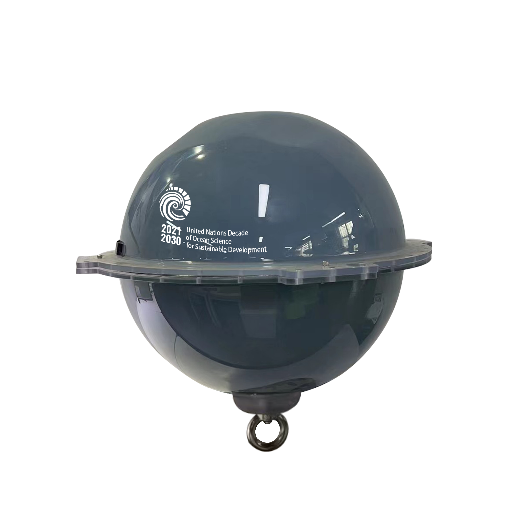
FIO Developed New-Generation Floating Ocean Buoys Based on the UN Ocean Decade Program
Through the Ocean Decade “Ocean to Climate Seamless Forecasting System (OSF)” Program, the research team of the First Institute of Oceanography of the Ministry of Natural Resources (FIO, MNR) has developed the new-generation intelligent global navigation satellite system (GNSS) floating ocean buoys featuring low cost and high precision, which marks a new opportunity for significantly improving ocean observation and monitoring capabilities. On February 2, 2023, the great breakthrough in marine technology was published on the official website of the UN Ocean Decade.

New-generation floating ocean buoys
With the help of GNSS signals, the new-generation GNSS floating buoys independently developed by the team led by Qiao Fangli, chief scientist of the OSF project and a researcher at FIO, can accurately obtain 10 parameters including spatial position, time, wave height, cycle, wave direction, surface flow rate, surface flow direction, sea surface temperature, sea surface salinity, and content of water vapor in the atmosphere.
The achievement is based on the long-term original research by the team led by Qiao Fangli, a member of the UN Ocean Decade Advisory Committee. The research shows that small-scale waves play an important role in large-scale ocean circulation and global climate change by modulating upper ocean mixing and air-sea fluxes. Therefore, wave observation is not only of great significance in itself but also crucial for the accurate prediction of large-scale ocean circulation and global climate change.
In history, there have been three major changes in global ocean observation: first, the ocean color satellite was launched in 1978, which achieved simultaneous observation of oceans on a large scale for the first time; second, a tropical moored ocean buoy array was built in the 1980s to form a worldwide fixed-point continuous observation network for tropical regions around the world and greatly promote the monitoring and prediction ability of El Niño-Southern Oscillation (ENSO); third, a broad-scale global array of temperature/salinity profiling floats (Argo) was developed at the turn of the century, with about 4000 Argo floats currently in operation for observation of one profile every 10 days to achieve real-time, three-dimensional monitoring of the ocean. Argo is also an important component of the global ocean observation system (GOOS) jointly led by the Intergovernmental Oceanographic Commission (IOC), UNESCO. Despite the enormous efforts of countless scientists and technologists around the world and many technological breakthroughs, high cost remains a bottleneck for ocean observation.
Since 2016, through in-depth multi-disciplinary marine cooperation, the team has overcome technical challenges in buoy hardware design and data processing with the help of Beidou, GPS, GLONASS, Galileo, and other kinds of GNSS satellites. The achievements include low-cost, high-precision, real-time online positioning with GNSS single stations, real-time online inversion of multiple factors including wave elements and water vapor content, wide wave spectrum expansion and capture, multi-factor encoding feedback and control in combination with Beidou short message communications, low-power high-performance algorithm optimization, and buoy minimizing with optimization of wave resistance. These independent technological breakthroughs have greatly improved the accuracy of inversion of wave and water vapor content in the atmosphere, avoided the service cost of precise differential positioning, and significantly relieved the burden on satellite communication.
Up to now, the team has carried out more than ten on-site observation experiments and compared the float with commonly used ocean observation equipment several times. The results show that the observation accuracy of the float differs from that of the precision wave measurement equipment such as "Wave Rider" by only a few centimeters, yet with a much lower observation cost. The cost of the new-generation GNSS buoys is only 10% of that of commonly used observation equipment around the world.
Technological innovation in cost reduction is particularly important because high cost has hindered the development of global ocean observation systems. Despite the significant progress made by humanity in the past half century, ocean observation still faces challenges from high cost and sparse coverage, which directly affects people's scientific understanding of ocean processes and limits the accuracy of predictions and forecasting of ocean and climate.
The team has developed several models of GNSS buoys. The basic buoy features a basic configuration and can obtain the above 10 parameters at the same time. By adding parameters such as wind, temperature, humidity, and pressure of the sea surface atmosphere, real-time monitoring of global sea-air flux can be achieved, and the contribution of waves can be taken into consideration in the calculation of sea-air fluxes to obtain more accurate data. By adding temperature-salinity chains, the temperature and salinity structure of the upper layers of the ocean can be measured. And again with artificial intelligence, internal waves in the ocean can be accurately captured. Water sound can also be measured to monitor marine mammals and protect the marine ecosystem.
The newly developed GNSS float is smart as it can encrypt observations autonomously according to objective needs (high-wave areas, internal waves, ocean disasters, and so on). Further technological breakthroughs will be made, and it may be possible to detect vortices and accurately measure sea levels around the world in order to strengthen the protection of coastal regions worldwide.
Link: Liu et al, 2022, Real-time precise measurements of ocean surface waves using GNSS variometric approach. International Journal of Applied Earth Observations and Geoinformation, 115, 103125, https://doi.org/10.1016/j.jag.2022.103125.


